
Alexander Mustard/2020VISION / Underwater shot
Dorset 3Deeper
Dorset 3Deeper
Peter Tinsley / Dorset 3Deeper video
Monitoring seabed habitats is full of challenges – one of the biggest is underwater visibility. Imagine trying to carry out a survey where you could only see a few metres in any direction. You can take photographs of small sections, but you can’t pull back to see the wider picture. We are so used to aerial surveys – from satellites down to drones, that we take it for granted, but in the sea, we are much more restricted.
Remote-sensing acoustic surveys, such as DORIS, have been a gamechanger in recent years - providing unprecedented detail over large areas, at a scale down to about 1:5000. This means we can “see” the physical structure of the seabed - rocks, ledges, sediment banks and ripples – but rarely can we differentiate areas of biological cover. These texture maps are great for planning more detailed surveys, but to understand what is living there and how it is changing, we are generally limited to taking lots of point samples (photos, grab samples etc.) and tying to interpolate between these points.
Until now.
Dorset Wildlife Trust was the winner of the Sea-Changers 2021 Innovation Fund and this allowed us to try out a completely revolutionary method of monitoring change in underwater habitats. Photogrammetry involves the stitching together of hundreds, if not thousands of overlapping photographs to create not just a single composite image, but a detailed three-dimensional model at sub-millimetre resolution. This provides a bridge between the scales of remote acoustic surveys and individual seabed photos and allows an impossible view of the seabed as it allows the viewer to rise above the seabed without it disappearing into the murk. It also allows detailed measurements to be taken, meaning that repeat surveys can be used to detect change.
For more information, read our report on using photogrammetry to detect change in seabed habitats.

Dorset 3Deeper map

Ross coral
Ross corals (not a true coral, but a calcifying bryozoan) form slow-growing, fragile colonies on the seabed, up to 80cm across. Their size and distinctive appearance make them ideal subjects to study change over time. Many colonies can be seen to grow between the two visits to the site, but some have been damaged, or disappeared altogether.
Further surveys in the future will help to understand the health of the ross coral population and this could be used as an indicator of the overall health of rocky habitats such as these reefs.
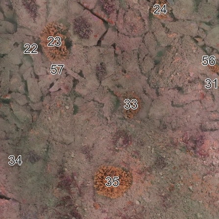
Detail of area where several ross coral colonies disappeared between Oct 2021 (left) and Jun 2022 (right)
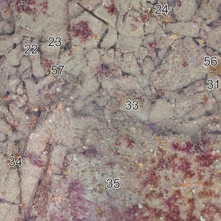
Detail of area where several ross coral colonies disappeared between Oct 2021 (left) and Jun 2022 (right)
